New Licence Applications To Expand Footprint In Western Australia
Greatland Gold plc (AIM:GGP) has lodged two applications for new exploration licences adjacent to existing licences at the company’s 100% owned Ernest Giles project in Western Australia.
The two Exploration Licence applications of Mount Smith (E38/3612) and Welstead Hill (E38/3613) cover a total area of 1,070 sq. km and join existing tenure at the Ernest Giles project located approximately 250km north-east of Laverton in the goldfields of Western Australia.
These new applications increase the footprint of the project from 880 sq. km to 1,950 sq. km. The new licence applications cover a prospective Archean greenstone rock sequence and were acquired following an internal review of historical and recent regional exploration data which concluded the broader project area is prospective for gold, nickel and base metals mineralisation.
CEO, Shaun Day, said that ahead of the expected grant of the licences, Greatland will focus on enhancing its targeting criteria and refine locations for future drill holes.
“The new licences represent an excellent opportunity to double the size of our footprint across the underexplored Ernest Giles greenstone belt,” Mr Day said.
“Following a detailed internal review of exploration data, we have identified compelling structural targets in an area containing dense and magnetic units of Archean greenstone sequences, with potential for gold, nickel and base metals mineralisation.
“This aligns with our strategy to seek to discover Tier 1 deposits both through the ramp-up of exploration activities across our existing 100% owned licences and by identifying new opportunities that can bring value to Greatland. We look forward to reporting progress on the two applications in due course.”
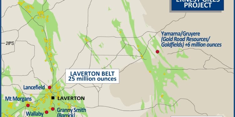
The Ernest Giles project covers a sequence of greenstone rocks typical of the Archean goldfields of Western Australia which host large gold camps such as Kalgoorlie, Leonora, Laverton, Mt Magnet and Jundee.
The project is located approximately 250km north-east of the town of Laverton. The gold prospective greenstone sequence at Ernest Giles does not outcrop. Thickness of the cover sequence ranges from around 120m to more than 300m across the broader project area. Consequently, with no outcrop, the project has not been subject to extensive historic exploration activity.
A recent internal review of historical and recent regional exploration data including solid geology interpretation based on detailed aeromagnetics and ground gravity, integrated with multi-element surface geochemistry and multi-element downhole geochemistry highlighted compelling structural targets with broad scale intense bedrock alteration.
The area contains both dense and magnetic units interpreted to be buried Archean greenstone sequences as shown by bedrock drilling within parts of the project. This supports the potential presence of large mineral systems in prospective rocks and recognition that the greater project area is prospective.


