Promising Indications From Bosnia & Herzegovina Surveys To Date
Adriatic Metals PLC (ASX:ADT/LSE:ADT1) has received the a permit to explore permit 32 sq. km of new concession areas in originally granted in Bosnia & Herzegovina in 2020.
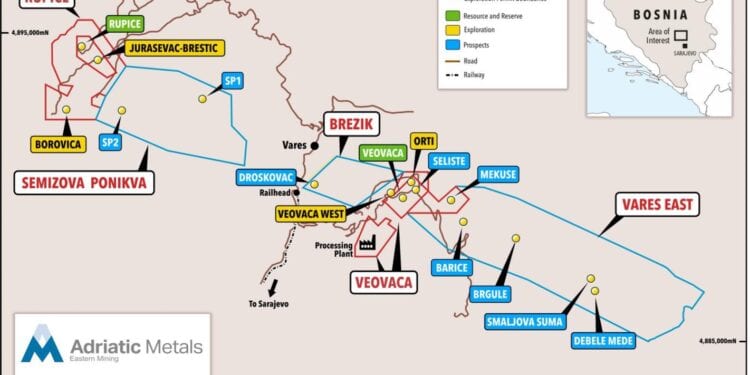
In September 2020 the company was awarded the three new concession areas totalling 32 sq.km , namely; Semizova Ponikva, Brezik and Vares East.
At the time this was the largest mineral concession granted in Bosnia & Herzegovina. Adriatic has now received the Exploration Permit on the new concession areas which gives the company the right to explore using invasive exploration techniques, such as drilling and channel sampling. This increases the total concession area the company is permitted to explore from nine sq. km to 41 sq km.
CEO and Managing Director, Paul Cronin, said preliminary exploration activities were conducted ahead of the application for the new concessions areas in 2020. This consisted of soil and rock chip geochemistry and field mapping. This work identified a number of prospective targets, which are covered in the Vares Project Geology Presentation, as announced on 19 April 2021.
“We thank the Federal Ministry of Energy, Mining and Industry for their support in awarding us the Exploration Permit for the New Concession Areas,” Mr Cronin said.
“We look forward to commencing our exploration activities across this 32 sq. km of newly permitted ground in due course. In addition, I am especially excited with the initial results from the Radiometric Survey, which have better identified the size and continuity of the known alteration system through the Vares Project.
“The edges of this alteration corridor are strongly correlated with previously identified mineralisation and our existing exploration targets. This has identified exciting new target areas, which we will follow up with further field work and update the market in due course.”
Exploration work completed on the Vares Project to date has identified a number of high-priority targets and prospects. With a lack of geophysical data across the Expanded Concession Area to date, a close-spaced, heliborne radiometric and magnetics survey (Geophysical Survey) was conducted in April this year and an initial analysis of the results has been completed.
The analysis increases the company’s understanding of the Vares Project’s mineralising system, as well as further supports these Existing Exploration Targets as areas of high interest that necessitate further exploration. In addition, the Geophysical Survey has highlighted a number of other potential blind targets across the Expanded Concession Area, which the company will investigate further.
Radiometric Survey
Radiometric survey results have identified a large alteration system, which is consistent with the company’s prior understanding of the mineralising system from field observations and historical geological mapping. However, the radiometric data has better defined the size and continuity of this alteration system and shows a prospective corridor that runs centrally through almost the entire 22km of the expanded concession area’s strike length.
The radiometrics survey was designed principally to map alteration. Initial observations are that the known resources and existing exploration targets identified to date on the Vares Project, in general lie along the edges of these potassium-rich alteration hotspots. These edges are where alteration conditions appear to be most suited to massive sulphide-style mineralisation. This exciting initial observation not only explains the distribution of the existing exploration targets but also indicates a number of new areas of interest that are yet to be explored.
From the extensive knowledge the company has gained to date from developing the mineral resources at Rupice and Veovaca, the initial results from the magnetics survey confirm that structural complexity combined with favourable stratigraphy is associated with the mineralising system.
Regional anomalous rock chip samples taken in late 2020 on the western part of the Vares East concession area correlate well with structural complexities. In addition to these areas, the magnetic survey has highlighted a number of additional areas of structural interest on the Expanded Concession Area.
Likewise in the Rupice / Borovica area, a series of near east-west structural features are observed in the magnetic survey, which correspond to the existing structural and geological model for this part of the concession area.


