To Follow-up On Silver Discoveries At Nash Creek Project
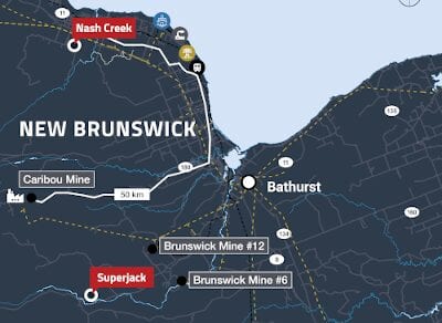
Callinex Mines Inc. (TSXV: CNX) (OTC: CLLXF) has mobilised a rig and personnel to commence an up to 4,000m drilling campaign to drill test 10 km of the 18 km Black Point Arleau Brook Fault.
The drilling campaign will focus on key drill targets identified during the 2020 soil sampling campaign at the 100% owned Nash Creek Project located within the Bathurst Mining District of New Brunswick.
President and CEO, Max Porterfield, said Callinex’s technical team has identified seven new target areas based on elevated, silver, lead, and zinc soil anomalies that cover over 10 km of the southern portion of the 18 km Black Point Arleau Brook Fault.
The Fault is spatially associated with two previously announced silver discoveries located 6.8 km apart. Drill hole NC20-313 intersected 28.6m of 57 g/t silver at a vertical depth of 120m including 16.5m of 94 g/t silver and NC19-306 which intersected 19m of 36.53 g/t silver, 0.52% lead and 0.38% zinc at a starting depth of 34.0m.
“We are excited to commence drilling at the Nash Creek Project as we focus on expanding upon the two silver discoveries made last year.” Mr Porterfield said.
“The focus of this drilling campaign is to test for silver mineralization along the 10km trend. If successful, this would put the company on a path to begin building a near surface silver resource at Nash Creek and with it the potential to further improve upon the maiden Preliminary Economic Assessment (PEA) that was published on the Bathurst Portfolio in 2018.”
Target Area 313
Target Area 313 is the northern 5.0 km of the sampled area where NC20-313 was drilled. Of the potential 5.0 km of strike, 3.7 km show strong linear correlations between silver/lead soil anomalies which supports the mineralisation intersected in NC20-313.
Additionally, this target area is associated with a low resistivity Induced Polarisation (IP) anomaly which suggests alteration similar to what was observed in NC20-313.
The elevated soil anomalies and IP resistivity low coincide with the interpreted conductive airborne Versatile Time Domain Electromagnetic (VTEM) anomalies previously identified which could suggest an increase in silver rich sulphide mineralisation similar to what was intersected in hole NC20-313.
Target Area 306
This target area is the southern 5 km of the sampled area where NC19-306 was drilled. As seen in the northern area, soil results in the southern portion define four targets recommended for drilling which span 1.7 km of prospective strike.
Of particular interest from the soil sampling results are highlighted by anomalous silver along the Fault.
The elevated silver anomalies are coincident with a much larger IP resistivity low anomaly and sits along a felsic/sediment rock contact. Drill hole NC19-306 was drilled vertically and did not test the main controlling fault. The 2006 VTEM survey that was completed was limited to a small portion of Target Area 313 and did not cover any of Target Area 306.
The silver mineralisation defined by the two discovery holes is interpreted to be hosted within faulted / brecciated rhyolites, with alteration consisting of silica, pyrite, galena +/- calcite interstitial to the felsic fragments. Mineralisation associated with faulting and the extensive soil anomalies defined along the Fault highlights the potential for additional silver mineralization to be discovered along the 10km trend.
Callinex is well funded to carry out the 4,000m drill campaign at Nash Creek and continues to carry out extensive drilling at the recently discovered Rainbow Deposit at the Pine Bay Project, Manitoba.
For further information please visit: https://callinex.ca/


