Empire Resources (ASX:ERL) has completed a detailed mapping, reconnaissance soils and geophysical targeting review at its wholly owned Nanadie Project in Western Australia.
Empire initiated ground exploration activities at Nanadie soon after grant of the final project tenement applications in 2021. Field work commenced with detailed geological fact mapping completed by experienced geological mapping consultancy, Compass Geological, closely followed by a +1,500-point reconnaissance soil sampling program.
Southern Geoscience Consultants (SGC) were engaged to review and reprocess all available historical and publicly available geophysical data. The reprocessed data allowed for completion of lithostructural interpretation and study to identify and rank targets of interest.
“The results from the soils programme and geophysical review are very encouraging. To have such strong geochemical anomalism identified from initial reconnaissance soils is extremely promising,” Managing Director, Sean Richardson, said.
“Empire will continue exploration at Nanadie with infill and extension soils sampling in conjunction with additional ground and airborne geophysics to define the limits of anomalism in preparation for aircore drilling. We look forward to updating the market as the Nanadie Project develops.”
Soil Sampling
Soil samples were collected from 1,537 sample locations at the Nanadie Project in October 2021. Soil samples were collected from shallow ~200mm hand excavated holes at 50m intervals on 200m and 400m line spacing.
The east west sample lines were selected to target potentially prospective areas identified by geological mapping, available geophysical imagery and historical sampling data. Samples were sieved to -2mm at collection in the field.
The field sample was then mechanically sieved to -180µm, pressed into a sample puck and assayed using a portable X-ray fluorescence (pXRF) analyser.
Standard certified reference material was analysed at one in 20 (5%) and duplicates at 1 in 25 (4%) to assist in assessing the veracity and efficacy of the program. 15% of the samples were also selected for further analysis to determine optimal soil sampling and analytical techniques.
Three additional analytical methods were assessed; pXRF of the course reject from mechanical sieving, and aqua regia digestion with a mass spectrometer finish (AR005/MS53) of both the -180µm and the course reject.
The data gathered by this orientation survey will be used to plan future soils sample programmes at Nanadie. Analysis of the data shows a strong correlation of chromium to nickel and copper. Assays greater than 300ppm Cr are considered anomalous and those sample above 600ppm Cr considered highly anomalous.
Outcropping pegmatites identified during detailed field mapping will be targeted by future soil sampling programs and assessed for Ta/Li potential. Regional gold anomalism ranges from 10ppb Au to 50ppb Au, well below the detection limits of pXRF analysis. The Company considers which analysis techniques are best suited to targeted elements based on the requirements of individual exploration programs.
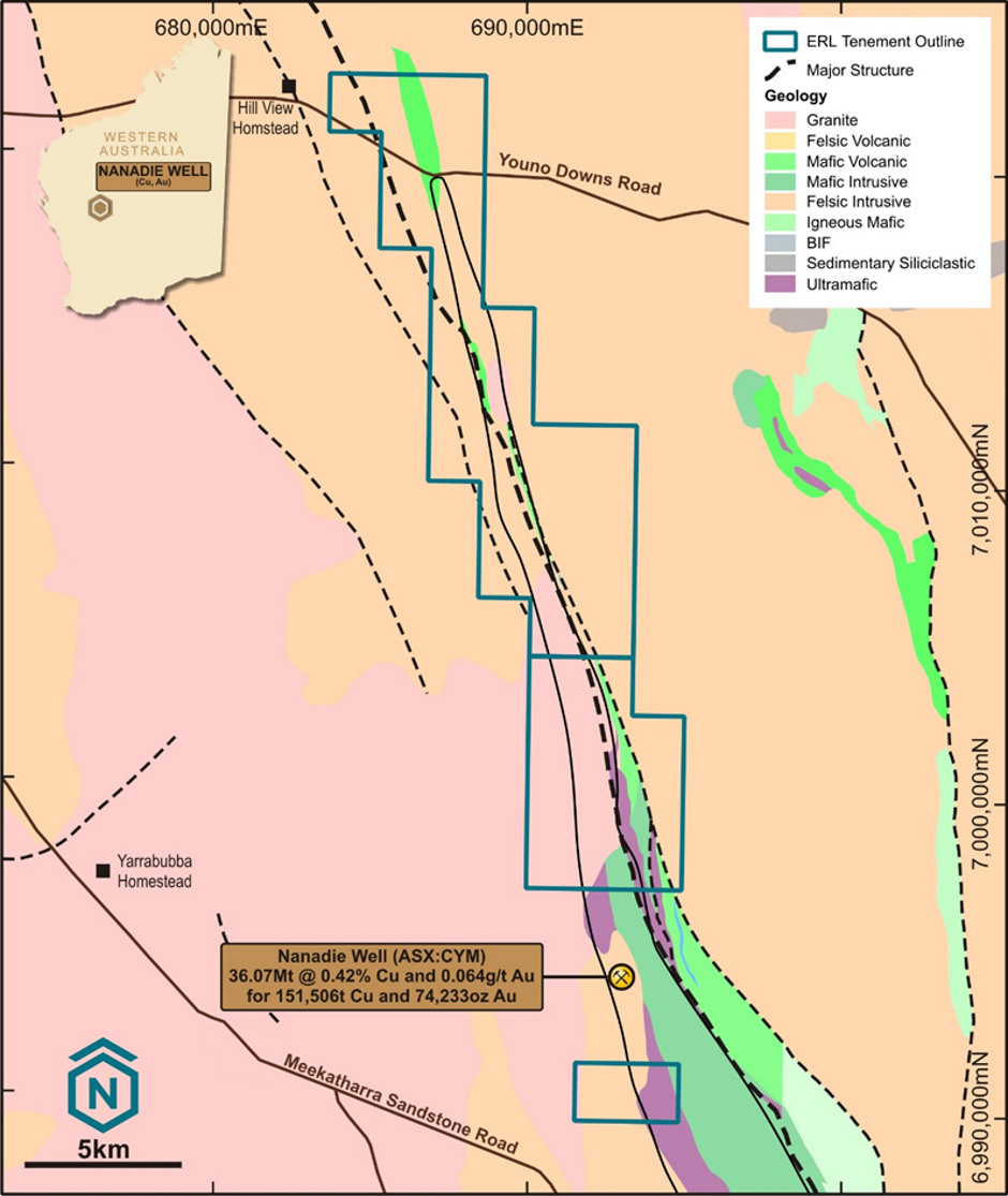
Empire Resources’ Nanadie Project is located 625km northeast of Perth and 70km southeast of Meekatharra in the Murchison District of Western Australia.
The project comprises two contiguous granted mineral exploration tenements (120.4 sq. km) covering the northernmost section of the Barrambie Greenstone Belt and a third granted tenement (6.9km2 ) south of Cyprium Metals Limited (ASX:CYM) Nanadie Well Copper Gold Project.
Cyprium’s Nanadie Well Copper Gold Project has a JORC 2004 Inferred Resource of 36.07Mt @ 0.42% Cu & 0.06g/t Au containing 151,506 tonnes of copper and 74,233 oz of gold.
The geological sequence hosting the Nanadie Well deposit is interpreted to continue north into Empire’s tenure. A regional shear, informally known as the Nanadie Well Regional Shear traverses the northern tenements from north to south.
For further information please visit: https://www.resourcesempire.com.au/


