Encounter Resources Ltd (ASX:ENR) has confirmed outcropping and regional copper mineralisation in geological activities at large scale Sandover copper project in Australia’s Northern Territory.
Managing Director, Will Robinson, said further on-ground mapping of Sandover is planned at the start of 2022 field season along with an airborne EM survey.
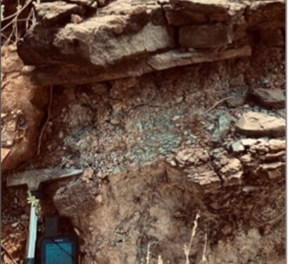
“Our systematic appraisal of copper potential in the Northern Territory continues to yield positive results. The mapped outcropping copper mineralisation at Sandover appears focused around grey shale units which are poorly exposed at surface and sandwiched between red fine grained to coarse-pebbly sandstone. This is the classic Zambian sediment-hosted copper mineralisation setting,” Mr Robinson said.
“Since acquiring the initial Sandover tenement in February 2020 the project area has been progressively expanded as new data was acquired including the identification of copper anomalism in multiple Government water bore cuttings analysed utilising a handheld XRF unit.
“Further mapping and sampling are planned along with an airborne EM survey to map the prospective geological units and also as a potential direct detection tool.”
Background
Sandover is located 170km north of Alice Springs and covers a major structural corridor on the southern margin of the Georgina Basin. Historical exploration at Sandover has mapped copper oxides at surface in a stratiform position extending over 20km of strike.
Sandover is interpreted to represent a locally preserved Neoproterozoic depocentre, overlain by more extensive Cambrian Georgina Basin sediments. The major elements of the classic Zambian style sediment-hosted copper system are present at Sandover including:
• Juxtaposition of Neoproterozoic sediments against crystalline basement
• Evaporites
• Reduced stratigraphic units to trap copper brines, within a red-bed sequence • Evidence of copper mineralisation event
Exploration Activity
In March 2021, drill cuttings from Northern Territory government’s water bore program were analysed by Encounter utilising a handheld XRF unit. Regional scale copper anomalism was identified in multiple water bore cuttings and consequently the Sandover project area was significantly expanded to ~4,000km2.
In October 2021, a field mapping program was completed at Sandover which confirmed outcropping copper mineralisation associated with a local grey shale reduced unit within a broader “red bed” sandstone sequence at Sandover. The setting is analogous to the Zambian ore shale in contrast to other sediment-hosted copper occurrences/deposits in Australia (Mt Isa, Nifty) where mineralisation is located in the overlying reduced shales.
During September to November 2021, historical geophysical datasets were compiled and integrated including regional gravity, magnetics, ASTER and the recent AEM lines completed as part of Geoscience Australia’s Exploring for the Future Program.
Following the observations during the October 2021 field visit and the reprocessing and integration of the available geophysical packages, Sandover was further expanded in November 2021.
For further information please visit: https://www.encounterresources.com.au/


