Takes To Air To Locate Source Of World-Class Phoenix Copper-Gold Mine
Golden Dawn Minerals Inc. (TSXV:GOM) is preparing to fly an airborne geophysical survey in early January over its Phoenix property at its Greenwood Precious Metals project in south-eastern British Columbia.
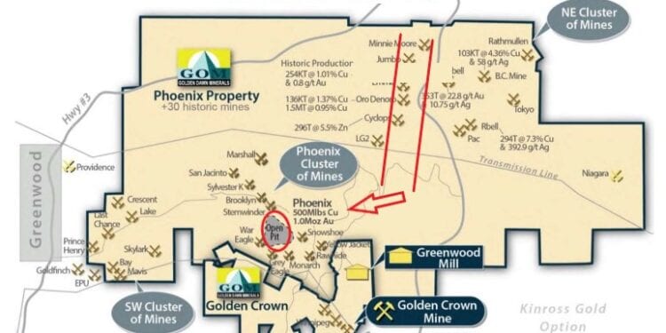
CEO Christopher Anderson said the area planned to be covered by the initial survey will include the area surrounding the historic Phoenix mine and the focus of the programme is to explore for the roots of the hydrothermal system that formed the Phoenix copper-gold deposit.
He said Golden Dawn is currently reviewing proposals for the survey and expects to sign a contract within the next few days.
The historic Phoenix copper gold mine was the largest producer in the Greenwood mining camp. Total production from Phoenix is documented as 26,956,525 tonnes of ore containing 30,715 kilograms of gold; 192,055 kilograms of silver and 930,050 tonnes of copper (BC MEMPR Paper 1986-2). The calculated grades are 3.45% copper, 1.02 grams per tonne gold and 7.12 grams per tonne silver.
Starting in 2021, Golden Dawn is planning a staged approach to search for a depth continuation of the Phoenix deposit, including:
- Airborne magnetic and electromagnetic geophysical survey
- Ground Geophysics (IP/Resistivity) in Selected Target Areas
- Compilation of Extensive Database of Exploration Data
- Drill Test High-Quality Targets
Limited exploration has been done to test the Phoenix deposit footprint at depth. One major problem for exploration of the Phoenix deposit at depth is that the Phoenix area is underlain by the Snowshoe fault, which is mapped as a listric-normal fault that truncates the host rocks and, in places, the deposit itself.
This means that the Phoenix deposit has likely been offset from its roots, the location of which is unknown. The Snowshoe fault is interpreted as an extensional structure that developed on the flank of the Grand Forks metamorphic uplift during the Eocene. Offset on the Snowshoe fault is predicted to be about one km based on regional mapping, so the roots of the Phoenix deposit could lie at least one km east of the open pit mine.
Approximately two km east-northeast of Phoenix there is a 2.4-km-long northerly trending corridor of skarn deposits that includes the Oro Denoro, Emma, Jumbo and Cyclops / Lancashire Lass, all hosted by the Brooklyn limestone.
The Oro Denoro skarn is thought to be related to the Lion Creek granodiorite intrusion, and the trend of the skarn deposits in the deposit corridor coincides with a lobe of the intrusion that extends in part along the lower contact of the Brooklyn limestone. This is the same contact that is mineralided at Phoenix. As such, it is interpreted that the Phoenix deposit could be the upper part of the hydrothermal system that formed the corridor of skarn deposits, before being offset by the Snowshoe fault. The roots of the Phoenix deposit should therefore lie in the area of the northeast cluster of skarn deposits of the Phoenix mine.
Production from the historic Oro Denoro mine for the period 1903 to 1917 totalled 124,001 tonnes containing 117 kilograms of gold, 954 kilograms of silver, and 1,691 tonnes of copper (BC MEMPR Paper 1986-2). Calculated grades are 1.36% copper, 0.94 grams per tonne gold and 7.7 grams per tonne silver. These grades are lower in copper but otherwise similar to those at the Phoenix deposit. In the early 1970’s several thousand tonnes were extracted from the Oro Denoro and processed at the Phoenix mill.


