Preliminary Exploration Work Shows Promise At Tuckers Hill
Golden Deeps Limited (ASX:GED) has reported “very encouraging” results from preliminary exploration work at the Tuckers Hill and Havilah Gold Projects in NSW.
At the Tuckers Hill Gold Project reconnaissance geological mapping has confirmed the location of the gold mineralised quartz reefs and historic workings that were previously investigated by Challenger Mining Corporation NL in 1985 and Geoservices Pty Ltd 2002. The historic workings cover an area of 1,500m by 800m along the ridge and eastern edge of Tuckers Hill, near the old gold mining centre of Hargraves.
The company says there are at least six parallel quartz veins that trend in a north-northwest direction. The highest grade vein is the Philips Vein that was rock chip sampled by C.W.Marshall and Associates in 1963 returning grades between 1.27g/t Au and 705g/t Au.
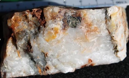
Gold mineralised sulphidic quartz reefs have been discovered during assessment of the Tuckers Hill workings. The quartz veins are of two types: steeply east or west dipping veins on the flanks of the hill and thick flatter lying veins on the top of the hill. These quartz veins are ‘leg reefs’ and ‘saddle reefs’ that have formed in the tight north-south trending Tuckers Hill anticline.
The leg reefs, including the Philips Vein, have been exploited via numerous shallow pits along the trend of the anticlinal axis. Several historical adits have then been driven from the east and west sides of the hill to intersect the quartz veins at depth. Mining has extended along the veins and upwards, sometimes to the surface where the stopes have broken through into the shallow surface workings.
Recent metal detecting is evident on the hill indicating the presence of coarse gold for which the Hargraves Goldfield, that includes Tuckers Hill, is renowned. There is also evidence of recent small-scale prospecting and mining on some of the quartz veins.
Rock samples have been taken of selected quartz veins and mullock dumps to validate the earlier sampling conducted by previous companies. The samples have been submitted to a commercial laboratory for gold and multielement analysis and the results will be reported when available. Not all quartz veins were sampled because they could not be found or because of their location.
Golden Deeps intends to conduct drilling at Tuckers Hill to test for extensions to the mined leg reefs and saddle reefs. The saddle reefs can be tested by drilling steep holes down the anticline axis from the top of the hill. The leg reefs, primarily on the eastern side of the hill can be tested by drilling shallow holes from the base of the hill towards the west.
Initial reconnaissance has also been undertaken at the Eldorado Mine on the Meroo Trend and at Great Western on the Maitland Trend.
Havilah Project, NSW
The Havilah Project, is located 20km east of Tuckers Hill and within the East Lachlan Fold Belt close to Peak Minerals Pty Ltd’s Hill End Gold Project and adjoining the southern boundary of Silver Mines Limited’s Bowdens Silver Project that has a Mineral Resource of 128Mt at 40g/t Ag, 0.38% Zn, 0.26% Pb.
Golden Deeps is initially targeting a north-south trending belt of Ordovician volcanics that form part of the Macquarie Arc that hosts the Cadia, North Parkes and Lake Cowal deposits. Copper was mined from the Cheshire Mine and processed nearby in a historic brick smelter. The mineralised Cheshire-Milfor trend extends from approximately 1km north of the Cheshire Mine and several kilometres south to the Milfor prospect. In total the Cheshire-Milfor trend has a strike length of approximately 4km. A small, shallow drilling program targeted the Cheshire Mine but the majority of the Cheshire-Milfor trend has not been drilled and has not been assayed for gold.
Golden Deeps plans to conduct rock and soil sampling along the belt of volcanic rocks that contains skarn alteration and several induced polarisation anomalies. Previous stream sediment sampling identified several copper and zinc anomalies that have not been followed up.


