Okapi Resources Limited (ASX: OKR, OTCQB: OKPRF) has commenced its summer field exploration programme across its exploration projects in the world-renowned Athabasca Region in Canada.
The company has recently completed significant satellite image data analysis over the Newnham Lake and Perch Projects which has generated numerous highly prospective targets.
Exploration program will include geologic mapping of structures, lithology and alteration, combined with geochemistry, primarily from rock samples.
The purpose of the exploration programme is to prioritise drill targets ahead of Okapi’s upcoming North American winter drilling programme.
“The Okapi team is excited to begin its maiden exploration programme. Okapi has a substantial land package comprising six project areas covering over 55,000 hectares,” Managing Director, Andrew Ferrier, said.
“Importantly, five of these projects are located along the margin of the Athabasca Basin where depth to the unconformity is relatively shallow, typically around 100 metres, making these ideal for targeting shallow high-grade unconformity-related Uranium deposits, and potentially near surface basement hosted Uranium deposits.
“The exception is the Middle Lake Project that lies adjacent to the formerly producing Cluff Lake Mine in the Carswell Impact Structure.
“We are particularly excited about our Newnham Lake and Perch Projects along the north-eastern margin of the Athabasca Basin which have the hallmarks to host potential tier-1 uranium discoveries.”
Newnham Lake and Perch Uranium Projects (100%)
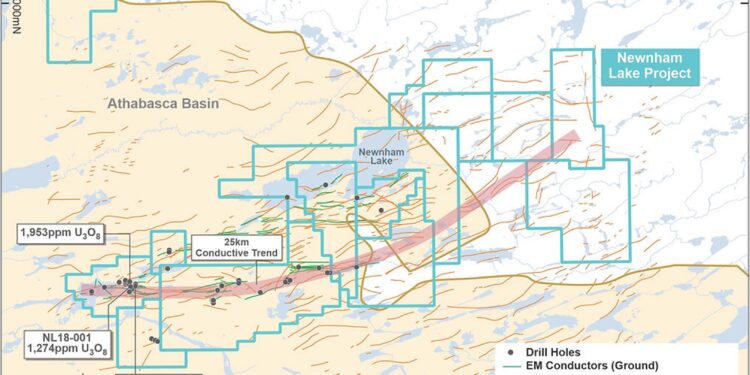
Okapi’s primary focus is on its 100% owned Newnham Lake and Perch Projects which straddle the north-eastern margin of the Athabasca Basin. Both Projects consist of 15 mining claims covering circa 18,500 hectares.
Historical drilling has encountered multiple ore-grade intercepts of between 1,000ppm U3O8 and 2,000ppm U3O8 in relatively shallow historical drilling within a 25km conductive trend. Importantly, the depth to the Athabasca Basin unconformity at Newnham Lake is approximately 100 metres deep mitigating the need to drill deep holes.
Okapi recently completed satellite image data analysis over the entire Newnham Lake and Perch Projects. This analysis included synthetic aperture radar (SAR) data, multispectral Sentinel and Aster data. The data collected generated a number of target areas.
The targets are positioned across east-west structural corridors, and the intersection of those with north-south and northeast-southwest trending faults. The areas north of the unconformity contact in exposed Archean rocks at Perch.
These areas have been identified as Archean Basement rocks at or near the surface that exhibit alteration and oxidation characteristics consistent with potential to host uranium mineralisation. The exploration programme will consist of geologic mapping of structures, lithology and alteration in detail, combined with exploration geochemistry primarily from rock samples.
Also identified from the satellite image analysis at Newnham Lake are the complex, laterally extensive structures associated with geophysical anomalies interpreted as conductors.
The recently completed image analysis will be combined with 3-dimensional geologic modelling of the historic surface and drill data that comprises approximately 200 drill holes (includes values up to 2,260ppm Uranium) with a goal of defining drill targets for the upcoming North American winter drilling season.
For further information please visit: https://www.okapiresources.com/


