8,000 Line Km Being Flown Over Yeungroon Project
Outback Goldfields Corp. (CSE: OZ) has commenced a large airborne geophysical survey over the prospective Yeungroon project in central Victoria, Australia.
The high-resolution, 8,000 line kilometre magnetic and radiometric survey marks an important step in Outback’s plans to systematically advance the Yeungroon project and refine exploration targets.
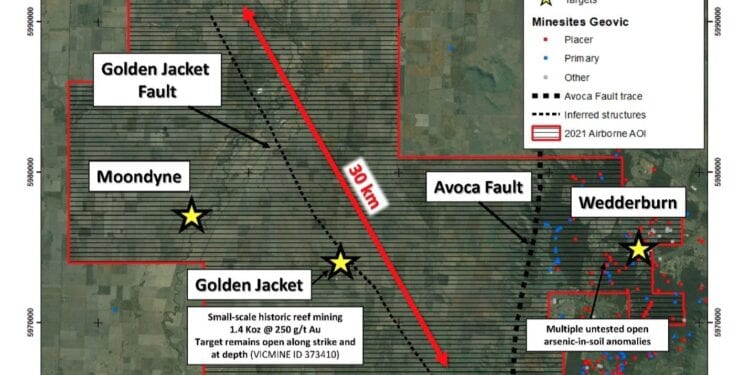
“We are excited to fly this geophysical survey over our Yeungroon Project. The high-resolution geophysical data will help our technical team identify and define new areas along the Golden Jacket fault, such as offsets or splays, as well as key property-scale structures in the Wedderburn area, worthy of detailed follow-up,” CEO Chrid Donaldson said.
“The execution of this survey is a significant first step in our plan to rigorously define new drill targets in the Yeungroon area, heart of the Victorian Goldfields.”
The Yeungroon geophysical survey is running concurrently with Outback’s previously announced 4,000 metre drill programme at the Glenfine Project, 160 km south of Yeungroon.
The 698 sq. km Yeungroon project is transected by the north-trending, crustal-scale Avoca Fault which separates the western Stawell Zone from the Eastern Bendigo Zone. The western side of the Yeungroon project contains the historic Golden Jacket hard-rock reef mine associated with the regional-scale, northwest-trending Golden Jacket fault.
Historic mining records indicate the Golden Jacket mine produced quartz-rich ore with grades of up to 250 g/t Au, however the vertical and lateral extent of mineralisation has yet to be tested by drilling.
Outback has retained Thomson Airborne to collect the fixed-wing, magnetic and radiometric data. The survey will be flown on east-west oriented lines spaced 100m apart.


