Additional Rig Added To Drilling Arsenal
Outback Goldfields Corp. (CSE: OZ) (OTCQB: OZBKF) has added an additional drilling rig to its ongoing and expanding exploration activities in the heart of the prolific Victorian Goldfields of Australia.
CEO, Chris Donaldson, said the additional drill rig has commenced activities at Glenfine, while diamond drilling is continuing at the Reef 2 to Glenfine South target.
“Over the last few months, we have assembled a top-notch exploration team on the ground, established a Ballarat-based site office and are now efficiently exploring,” Mr Donaldson said.
“The addition of extra drill rigs will aid in our testing of drill targets and our ultimate goal of making the next world-class discovery that the Victorian Goldfields are known for.”
Initial samples from Glenfine have already been sent to the lab for analyses.
Elsewhere, Outback is undertaking a target generation programme at Yeungroon
A remote sensing LiDAR survey over the Wedderburn target area is scheduled, while a property-wide RAB exploration programme is slated to drill 400+ holes.
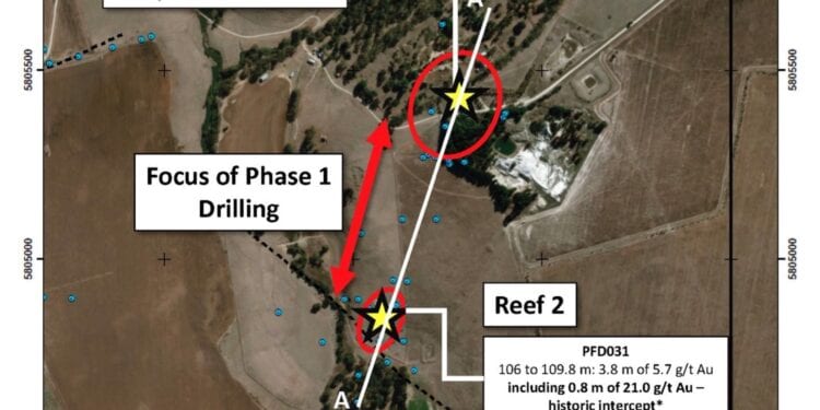
The current exploration programme at the Glenfine project is focused on targeting high-grade, quartz reef-hosted gold mineralisation. The first target area being tested is an approximately 400m north-south trending corridor of prospective geology between- and along strike- from the historic Glenfine South mine and the southern Reef 2 prospects.
Eight diamond drill holes have so far tested for mineralisation continuity along this trend. Initial samples have been sent to the lab for analyses.
The focus for the reverse circulation (RC) drill will be to test for parallel structures in the Glenfine to Reef 2 corridor in a cost-effective manner.
Additional targets on the Glenfine project, such as British Banner, will be drill tested once land access has been finalised and drilling along the Reef 2 to Glenfine South corridor is complete.
Previous exploration drilling at Glenfine intersected numerous intervals of significant gold mineralisation at both target areas, such as 3.8m of 9.0 grams per tonne (g/t) Au with 1.3m of 23.4 g/t Au in hole CCD01 at British Banner and 3.8m of 5.7 g/t Au with 0.8m of 21.0 g/t Au in hole PFD031.
The current exploration programme at the Yeungroon project is focused on understanding the structural setting and associated geochemical footprints of known mineralization (e.g., Golden Jacket and Wedderburn targets) as well as defining additional high-grade, reef-hosted targets along key faults.
Ageospatial services contractor has been engaged to complete a high-resolution LiDAR (light detection and ranging) survey over the eastern side of the property including the northern extent of the Wedderburn goldfield.
Previous exploration in these areas identified numerous untested, north-trending arsenic-in-soil anomalies considered prospective for reef-hosted gold mineralisation.
The LiDAR data will be used to identify all areas of historic disturbance potentially related to surface mineralization and to provide robust topographic control for future modelling and ground-based surveys. Data from the recently completed property-scale airborne geophysical survey at Yeungroon has been received and is being interpreted. Structural targets are currently being refined and prioritised.
Follow up plans to systematically investigate the geophysical targets are being finalised. Over 400 RAB (Rotary Air-blast) holes are proposed with an average depth of 10m. These holes will test prospective faults and structural intersections below widespread post-mineralisation cover rocks. Contracts and land access agreements for the programme are being finalised.


