Siren Gold Limited (ASX: SNG) has obtained promising results in exploration activities at its Alexander River and Lyell projects in New Zealand.
Highlights
• AX89 drilled in the McVicar West shoot intersected 2.2m @ 10.2g/t Au. This hole was drilled 100m down plunge from AX85 that intersected 2.5m @ 358g/t Au.
• The intersection of the McVicar West shoot in AX91, extends the shoot 750m below Level 6 of the McVicar mine. Together the McVicar East and West shoots combined, now extend for over 1.3kms below outcrop.
• A 100m long mineralised zone was identified at Lyell based on sub-crop and float samples. Samples with disseminated acicular arsenopyrite assayed up to 4.8g/t Au while samples that also contained thin <4mm grey quartz veinlets included assays of 37g/t Au, 22g/t Au and 6g/t Au.
• The Lyell soil and rock chip results and their similarities with Alexander River mineralisation are very encouraging. Siren has applied to the Department of Conservation (DoC) for an Access Agreement to allow drilling at Lyell.
Alexander River
Recent Exploration
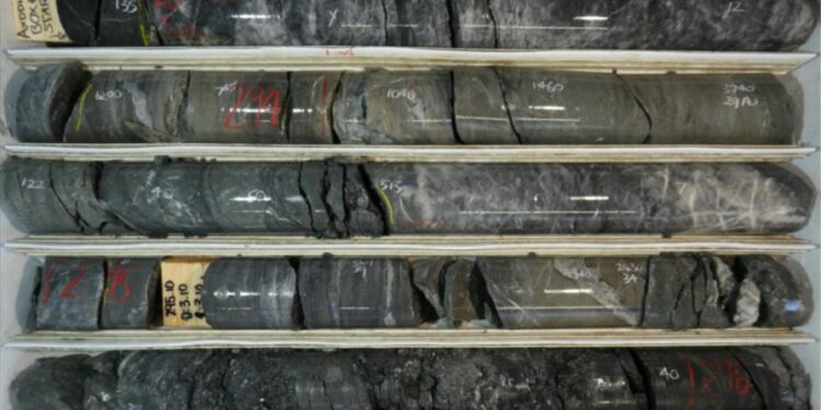
AX89 intersection comprised a 2.3m strongly mineralised zone, with a 0.6m quartz reef showing visible gold on the hanging-wall, followed by 1.6m of disseminated acicular arsenopyrite mineralisation. This zone returned 2.3m @ 10.2g/t Au from 293m.
AX91 intersected the McVicar West shoot 100m down plunge from AX89 with results awaited. This intersection extends the McVicar West shoot to 750m down plunge below Level 6 of the McVicar mine, with the McVicar East and West shoots combined, now extending them for 1.3kms below the outcrop.
AX84 (2.5m @ 358g/t Au), AX85 (2.1m @ 18.0g/t Au) and AX89 (2.3m @ 10.2g/t Au) have intersected high grade mineralisation around the inferred NW-SE trending fault.
AX45 (2m @ 26.8g/t Au) and AX47 (5m @ 9.1g/t Au, including 1.6m @ 27.9g/t Au) in the Loftus-McKay shoot also intersected high grade mineralisation adjacent to the fault.
Diamond drillhole AX89 was drilled 100m down plunge of AX84 and intersected 2.3m@ 10.2g/t Au on the other side of an interpreted fault. The mineralisation was intersected around 40m west of AX84, but down plunge, indicating that displacement across the fault is largely strike slip. If this interpretation is correct, then the Loftus-McKay shoot should have a similar displacement across the fault.
AX98a was drilled between AX80 (2m @ 8.0g/t Au) and AX85 (2.1m @ 19.3g/t Au) intersected a strongly mineralised zone, comprising a 0.4m quartz reef and around 1.5m of acicular aspy mineralisation with results awaited.
AX96 and AX97 were drilled off Pad 44 to try and intersect the Loftus-McKay shoot but did not intersect any significant mineralisation. A dolerite dike has been interpreted from a ground magnetic survey north of Loftus-McKay. The dike strikes E-W and appears to be offset by around 150m, indicating that there may be a NNW-SSE fault in Mullocky Creek.
This interpreted fault has not been previously recognised. This fault would also offset the Alexander reef track and the Loftus-McKay shoot. If the Loftus-Mckay shoot has been offset by around 150m to the north across this fault, then the shoot would not have been intersected by diamond drilling to the north of Pad 28.
Alexander Mineral Resource Estimate (MRE)
The Alexander Mineral Resource Estimate (MRE) is currently being completed by Entech and will be reported in July.
Lyell
Recent soil sampling at Lyell shows a NW trending gold anomaly that intersects the anticline around the Alpine United mine. The anomaly extends for over 3kms, as shown by the red dotted line in Figure 6, where it potentially intersects a syncline around the United Victory mine. The Break of Day mine is also located along this anomaly.
The soil samples along the NW gold trend identify several anomalous areas shown by the black circles in Figure 6. These may represent mineralised shoots similar to Alexander River.
As previously reported, an outcrop of acicular arsenopyrite mineralisation was found along this gold anomaly at Mt Lyell. The outcropping mineralised zone extends for around 50m along strike and may be up to 10m thick.
This mineralisation looks very similar to the disseminated acicular arsenopyrite mineralisation found at Alexander River. Rock chip results ranging from 0.7 to 8.6g/t Au, along with visible gold, were found in quartz float at the Break of Day mine 1km to the south.
The gold soil anomaly at Mt Lyell North was mapped. Outcrop is poor, but a 100m long mineralised zone was identified based on sub-crop and float samples.
These results, along with the similarities to Alexander River, are very encouraging. Siren has applied to the Department of Conservation (DoC) for an Access Agreement to allow drilling.
For further information please visit: https://www.sirengold.com.au/site/content/


