3,000m Discovery Drill Programme At Einarson And Rogue
Snowline Gold Corp. (CSE: SGD) is set to commence its fully funded 2021 Yukon exploration programme in the first week of June.
Exploration will focus on its flagship Einarson and Rogue projects in the Selwyn Basin, Yukon Territory, with targeted programmes at its regional assets.
Discovery drilling at Einarson and Rogue will test multiple zones of high-grade gold found on surface (up to 34 g/t Au at Einarson and up to 152 g/t Au at Rogue) and assess structural and lithological controls on mineralisation.
CEO and Director, Nikolas Matysek, said is targeting 3,000m of drilling at Einarson and Rogue, with initial drill testing of other projects as warranted by results.
Snowline’s COVID-19 operational plan has been approved by the Yukon Government and will safeguard Snowline’s employees, its service providers, and the Yukon communities in which it operates. The company has also been awarded a C$40,000 grant from the Yukon Government to support its initial exploration of the nearby Ursa project.
“We have a lot to look forward to this season,” Mr Matysek said.
“Our fully-funded exploration campaign is set to test some very low hanging fruit, including some previously untested ideas. We’re excited to put the initial drill holes in at Einarson’s ‘Mars NE’ zone and Rogue’s “Valley” zone, both of which have significant potential.”
Limited exploration to date in the broader Rogue, Einarson and Ursa area has focused largely on constrained targets and deposit models.
“At Snowline we’ve recognised the potential for a continuum of near-surface gold deposit types across these three adjacent Selwyn Basin projects,” said COO, Scott Berdahl.”
“Possible end-member analogues include some of the world’s better-known districts and deposits, like Nevada’s Carlin trend and Australia’s Fosterville and Bendigo districts for Einarson, Alaska’s Fort Knox deposit for Rogue, and Russia’s Sukhoi Log deposit for Ursa.”
Einarson
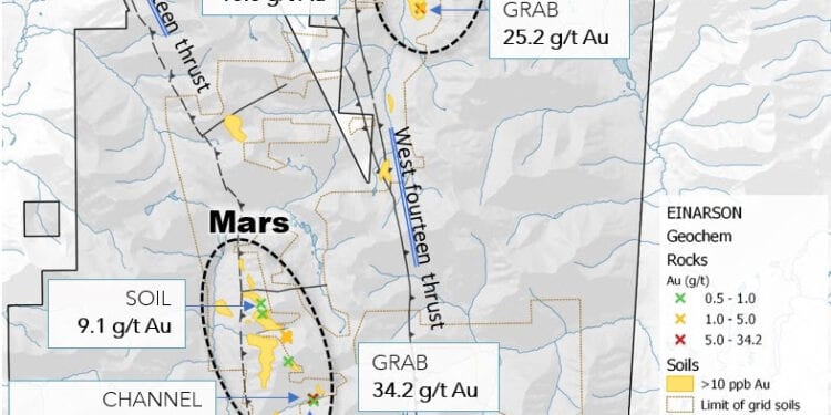
Einarson encompasses multiple kilometres-scale soil and stream sediment anomalies in carbonate and siliciclastic stratigraphy prospective for Carlin-type and epizonal orogenic gold deposits. The 2021 drill programme will test the Mars NE zone, a 3-kilometre zone of anomalous gold in soils accompanied by at least three interpreted source areas for mineralized quartz float, which commonly assays in the range of 1 to 7 g/t Au, up to a maximum of 25 g/t Au.
Early season geochemical, drone surveying, trenching and mapping work at Mars NE will allow for efficient use of the drill and increase the odds of a successful drill discovery.
Additional mapping and sampling will aim to identify the source area for another mineralised quartz float train in the Avalanche Creek zone, discovered in late 2020 roughly 12 km south of Mars NE along strike of a regional fault structure. Twenty-two grab samples of the float train averaged 7.8 g/t Au and graded up to 34.2 g/t Au.
Regional prospecting will seek to identify other instances of this newly-identified style of shallow orogenic mineralisation along this relatively unexplored trend, and along adjacent, parallel regional fault structures and anticlines that could host similar mineralisation.
Rogue
At Rogue, grid and contour geochemical sampling is planned to infill data gaps at the Valley zone, where surface grab samples with visible gold have assayed up to 152 g/t Au and—distal to the visible gold and other known showings—a single soil line yielded a gold-in-soil value of 4.6 g/t Au.
Drone supported, high-resolution orthophotography and digital elevation model generation will provide a baseline for mapping and geochemical sampling. A second drone survey will provide detailed magnetic information over the Valley zone, providing the 3D geometry of the intrusion and associated alteration below the surface. All of the above will be used for targeting of discovery drilling in the Valley zone.
Contour soil sampling, prospecting and geological mapping will be performed across the greater Valley-Gracie trend, and on secondary claim blocks, to assess for additional targets. If conditions permit, a broader drone-supported aerial magnetic survey will extend from the Valley zone to include the Gracie zone and the remainder of a prominent nine km east-west trend of hornfels connecting the zones.


