Expands Total Land Position To Approximately 90,000 Hectares In Yukon
Snowline Gold Corp. (CSE: SGD) has staked additional claims, significantly expanding its land position around its 100% owned Rogue, Rainbow, Cynthia, and Ursa projects in the east central Yukon.
In total, 782 new claims were staked for an additional 18,864 hectares. This brings Snowline’s mineral tenure in the Yukon to 89,724 hectares across its seven projects.
CEO, Nikolas Matysek, said the new claims were strategically staked to cover structures, trends, and gold anomalies that extended beyond the bounds of its original holdings.
He said the enhanced land position cements Snowline’s cornerstone position in an emerging gold district in the prospective Selwyn Basin.
“Snowline launched with seven high quality exploration projects throughout the Yukon and an extensive privately owned exploration database built over decades” Mr Matysek said.
“A comprehensive geological review led by Dr. Quinton Hennigh and Dr. Craig Hart determined that the bulk of Snowline’s properties may only cover the tip of the iceberg.
“This new staking has expanded Rogue, Rainbow, Cynthia, and Ursa’s footprint to better cover high priority exploration targets and to cement Snowline’s cornerstone position in the Selwyn Basin.”
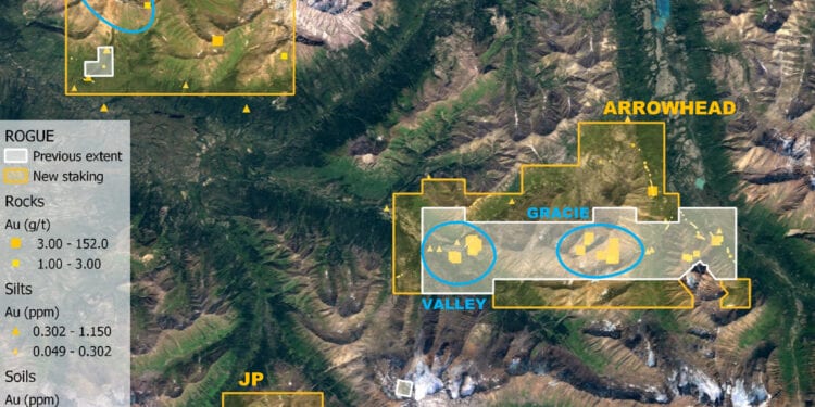
Recent staking has expanded the Rogue Project by 4.6 times to 11,227 hectares covering high priority gold targets that Snowline is intending to further explore in the upcoming season.
Snowline’s mineral tenure at Rogue was significantly increased with the staking of 321 new claims in three blocks—Arrowhead, Old Cabin and JP—targeting reduced intrusion related gold systems associated with members of the Cretaceous-aged Tombstone Plutonic Suite.
Holdings around the project’s primary Valley and Gracie targets on the Arrowhead block were increased by 117 claims (2,422 ha) to better cover the existing target zones and to secure prospective areas in their vicinity.
Historical geochemical sampling by previous operators included two drainages downstream of the newly-staked ground with reported gold-in-silt concentrations of 160 and 100 parts per billion gold. Elsewhere, a soil sample returned 1.32 grams per tonne gold where an inferred fault striking north northeast from the Gracie zone crosses a contour soil sampling line, some 3.5 km northeast of the central Gracie target area.
An additional large block, Old Cabin, comprising 176 new claims (3,569 ha) was staked to connect and expand claim holdings over a suspected buried intrusive stock inferred from a small (roughly 200 m) granodiorite plug within a 2 x 4 km magnetic anomaly. Historical grab samples within this zone include quartz vein material assaying 8.7 g/t Au, and sulphide-rich skarn assaying 5.3 g/t Au.
Elsewhere on the block, historical grab samples of quartz vein material have assayed up to 10.0 g/t Au. Streams draining the claim block consistently returned values in the hundreds of parts per billion gold.
One particular stream draining from the magnetic anomaly returned gold-in-sediment values ranging from 233 to 1150 ppb Au. It is thought that a buried intrusion at Old Cabin could have an intact carapace at its top, with increased potential to host a significant reduced-intrusion-related gold deposit.
The third block, JP, comprises 28 new claims (563 ha) above and around a 900 by 600 m exposure of an intrusive stock 7 km southwest of the Valley target. Historical sampling found subparallel gold-bearing quartz veins averaging two cm in width within and adjacent to the intrusion, commonly assaying between one and four g/t Au with samples up to 36.0 g/t Au.
Rainbow
Recent staking has expanded the Rainbow Project 10 times, now totaling 1,255 hectares.
Rainbow covers a gold and pathfinder element soil anomaly associated with surface alteration caused by a recently discovered intrusion. Staking expands the property to include parts of the historical soil anomaly previously outside its boundaries, including a northwest zone with anomalous gold in soils to 0.93 g/t Au, silver in soils exceeding a 100 g/t Ag assay limit, and anomalous bismuth, tungsten and antimony. The new land position also covers a 3 km magnetic signature extending eastward from the soil anomaly.
Cynthia
Recent staking has expanded the Cynthia Project six times, now totalling 1,399 hectares.
Cynthia covers an area of gold mineralisation between two adjacent exposures of a Cretaceous Tombstone suite intrusion. Mineralisation is controlled by district-scale fault zones and is especially intense in the central part of the project. Surface grab samples in these zones commonly assay from 200 ppb to three grams per tonne gold, with values up to 16 g/t Au in a central zone. Cynthia is along strike of the past producing Plata silver mine and is within 8 km of an inactive heavy equipment winter access trail that connects to the North Canol Road.
This staking gives secures a wider margin around known mineralised zones and covers additional prospective ground on the altered shoulders of two intrusive exposures.
Ursa
Recent staking has expanded the Ursa Project 54 times, now totalling 7,755 hectares.
Ursa cover a 9 km trend of anomalous gold in stream sediment and soil samples, thought to be associated with sulphide minerals hosted in tightly folded Cambrian and Ordovician shales and cherts. Ursa also hosts a separate, 14 km-long trend of elevated to highly anomalous zinc along with elevated silver, copper, molybdenum, nickel and vanadium, thought to be associated with Devonian age enriched black shales.


