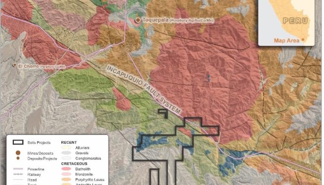
Solis Minerals Ltd. (ASX: SLM, TSXV: SLMN) has received confirmation of grants for a series of largely contiguous tenements totalling 3,200ha in the highly prospective southern Peruvian Copper belt, located some 15km to the southeast of the world class Toquepala Au/Ag/Cu/Mo Porphyry Mine. The new project will be called the Cinto Project.
The company has completed the initial compilation of available geological and other data sets over the area, including the acquisition of new remote-sensing satellite data (comprising the Worldview-31 platform, amongst others) covering Cinto and Solis’ other Peruvian copper projects.
Specialist consultant interpretation of this new satellite data has highlighted several priority zones of favourable alteration – particularly at Ilo Este- which has never been tested.
Field geological teams will mobilise shortly to undertake detailed field checking, mapping and systematic sampling of the highlighted alteration anomalies in preparation for drill testing. Detailed Worldview-3 data has been acquired over Cinto and is being processed.
“This is an exciting development for Solis shareholders as the Cinto Project offers an opportunity to be the first exploration company to use modern exploration techniques on a staked area, located near one of Peru’s largest copper producers, Toquepala mine,” CEO Jason Cubitt said.
“With the same major structural controls, and similar rock type and age to Toquepala (57 Ma – 57 million years), we intend to advance this project to a drill-ready stage and offer Solis shareholders exposure to another world-class target in Peru’s Southwest copper belt. The Company remains fully funded for this year’s field season.”
Cinto Copper Project
The northern permits are underlain by igneous rocks of the Cretaceous Toquepala Group and the late Cretaceous-early Tertiary batholith related to the Toquepala porphyry mine some 15km to the northwest.
The regional Incapuquio fault crosses the permits and the underlying igneous rocks are covered by recent sediments, generally south of the fault and increasing in thickness to the southwest.
Several zones of hydrothermal alteration in the concessions are noted in published geological maps. The Company has recently acquired Worldview-3 satellite imagery to assist in rapid delineation of priority areas which will be followed up with geological mapping and rock sampling. The satellite data is currently being processed. Potential drill target identification would initiate permit applications for first-pass drill programs.
Ilo Este Copper Project
The Ilo Este (east) Project comprises four contiguous tenements covering an area of approximately 3,200ha. They are located about 110km northwest of the town of Tacna.
Exploration undertaken by previous owners at Ilo Este included 12 reverse circulation (RC) drill holes (2000) and 12 diamond drill holes (2014-16), which were successful in identifying copper-gold mineralisation and interpreted to be part of a Cu-Au porphyry system. Mineralisation is differentiated into two types:
1) Oxide zone – green copper oxide minerals (brocanite, atacamite, malachite, neocite, hematite and manganese oxides) with carbonate staining that occurs across both the southern and northern intrusion belts and occurring to depths of approximately 80m.
2) Hypogene mineralisation – copper sulphides (chalcopyrite-bornite-pyrite) occur as disseminations, in fractures and within quartz veins that occur as a random stockwork within porphyritic granodiorite and porphyritic quartz diorite of the northern intrusive belt.
Although it is thought that the parts of llo Este porphyry system may have been deeply eroded down to the potassic zone, there remains the potential to discover higher grade mineralisation in areas of the porphyry that have been less eroded as well as a lower-grade orebody within the remnants of the porphyry.
There is also potential for the intrusive belts to continue under cover to the south and east and to have been offset by a major fault (the Chololo Fault) striking to the northeast that could have offset the upper portion of the porphyry. This upper part could potentially host a higher grade phyllic zone of mineralisation.
The Company has recently undertaken Worldview-3 satellite imagery studies and is interpreting the data. Based on initial results indicating untested alteration, it is envisaged that further areas for exploration north of the Chololo fault will be subject to geological ground mapping, rock sampling, and renewed alteration domain interpretation.
South of the Chololo fault, in areas of recent geological cover, a ground magnetic geophysical survey will be undertaken in areas viewed to contain favourable underlying structural architecture to host porphyry-style intrusives. These programmes, combined with data from previous drilling, will allow drill planning to proceed in the coming months and permitting to be initiated.
Proposed Work Programmes
Cinto: Process Worldview-3 data, identify zones of interest. Mapping, prospecting leading to identification of potential drill targets. Initiate drill permitting leading to potential drill programs.
Ilo Este: Follow-up field visits to newly identified alteration areas. Mapping and prospecting leading to identification of potential drill targets (0-3 months). Follow-up south of regional fault with ground mag survey for additional targets. Initiate drill permitting leading to potential drill programmes in 2023.
Ilo Norte: Acquire Worldview-3 satellite imagery (0-3 months). Follow-up with field visits. Complete IP and ground mag surveys where practical. Initiate drill permitting leading to potential drill programs in 2023.
For further information please visit: http://www.solisminerals.com/


